 |
| It was more like the next 40 miles |
 |
| This was a 2 way road-posted at 55 mph |
On the map the road over the mountains looks quick-about 40 miles. Way wrong! It took us HOURS. The road was wild. It narrowed in spots to one lane, no guardrail, very steep. In one place the grade was posted at 16%. The steepest grade we had ever seen before this was 11% in Quebec. We couldn't drive faster than 30 miles an hour on this white knuckle ride. Finally,we drove down a hill and there was the ocean before us. We're not sure if it was the ocean view or the realization that we made it out alive that made us so happy.


 We turned north and drove along Highway 1 which follows the coast. It was beautiful. We did pass many signs on the road warning us of a mudslide ahead. Most were cleaned up but we could see the remains of the debris. There were also signs warning of tsunami danger zones.
 |
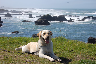
| Loving the beach |
 We turned north and drove along Highway 1 which follows the coast. It was beautiful. We did pass many signs on the road warning us of a mudslide ahead. Most were cleaned up but we could see the remains of the debris. There were also signs warning of tsunami danger zones.
We stopped for the night at a state park in Fort Bragg, California. Fort Bragg is a picturesque small town, however, we saw more homeless people here than we have seen anywhere. We stopped at the McDonalds in town and there were a number of homeless people lurking around the side and back area. In particular, there was a guy and girl and two dogs camped out on the grass leading up to the drive-through window. They had a sign saying they were hungry. We have never seen anyone begging at the drive-through window before. Then we saw a man who was clearly living in his car. It was loaded with junk, and three cats. It was hard to see inside the car because the windows were so filthy.

 |
| The California north coast is rocky; the south coast beaches are fine sand |

We did spend some time walking along the shoreline at the state park. This park is on the whale migration route and we were hoping to see a gray whale moving north. We didn't, but we did see harbor seals sunning themselves on some rocks just off shore. The state park ranger told us that we had to keep Sid away from the seals because dogs and seals share some diseases and seals carry a particular virus that Sid could catch.
Since Fort Bragg was so sketchy we moved north to a KOA campground. It is right on the ocean and we've been frolicking in the waves.
It's a good thing we stopped here because we found out that a massive mudslide landed in the middle of Highway 101 (the only route north along the coast). The state estimates it will take at least a week to clean it up and repair the highway-the road buckled up on both sides of the slide.
 |
| Mudslide on Highway 1, 60 miles south of Eureka, California |
We planned to head north on Highway 101 up to the Avenue of the Giants to see the giant redwoods. We will have to take a detour which is about a day long. Due to the unique geography of the area we have to go south, then cross back over the mountains and take Highway 5 north, then swing in from the north. We couldn't see the giant sequoias because of the snow and now mud is hampering us from these redwoods. We want to see the damn trees!!

 |
| Pacific Ocean view from our van |
Like the vids - poor Sid didn't see the wave coming - take a picture of the Sequoias on a post card and post we won't know the difference
ReplyDelete